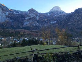
Hiking Routes in Hallstatt
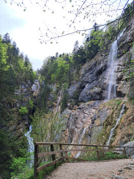
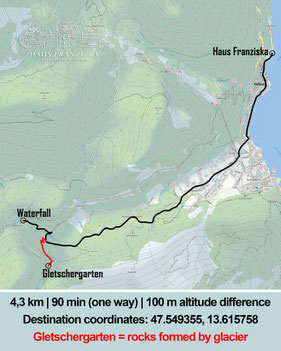
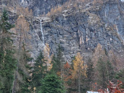
Waldbach Strub Waterfall & Gletschergarten
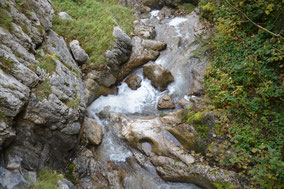
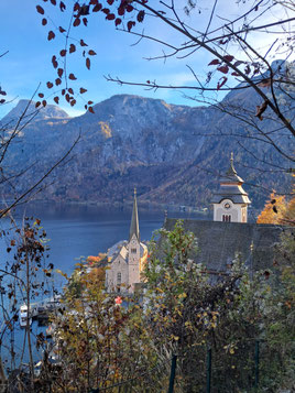
Waterfall in Echerntal Valley in Hallstatt
Difficulty: Moderate
4,3 kilometers | 90 minutes (one way)
100 m altitude difference
Destination: 47.549355, 13.615758
Gletschergarten = cool rocks formed by the glacier
Mühlbach Bridge
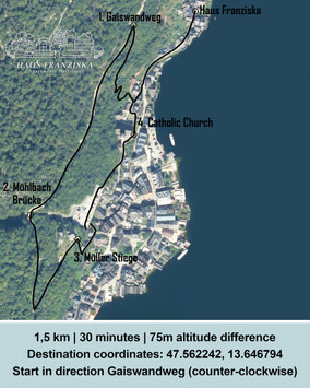
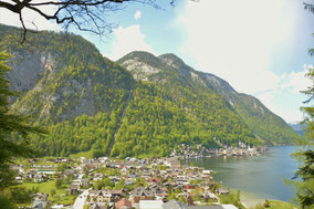
Roundtrip above and through Hallstatt.
Difficulty: Easy
1,5km | 30 min (round trip)
75m altitude difference
Destination: 47.562242, 13.646794
I would advise to start in direction Gaiswanderweg (counter-clockwise)
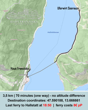
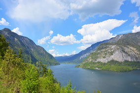
Ostufer Wanderweg
Difficulty: Easy
can turn back at any point
Destination: 47.590188, 13.666661
Last ferry to Hallstatt is at 18:50
Cost of ferry = 8€ per Person (2x4€)
Ufernwirt Seerauzn is a small restaurant
It is also possible to go further to the bus stop "Steeg Gosau" and return with the bus
Krippenstein Five Fingers
Winter: Snowshoe hiking
Difficulty: Easy
1,1km | 85 min | 50 m altitude difference
Destination coordinates: 47.528637, 13.692138
22-30 min with bus 543 (Hallstatt Nord -
Winkl b.Obertraun Dachsteinseilbahn Talstation)
OR 10 min by car
25 min cable car
hiking 30 min (one way)

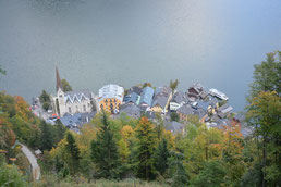
Goaßabankerl
Hidden hike with a nice view of Hallstatt.
Difficulty: Easy
2,3 km | 40 minutes (one way)
100 m altitude difference
Destination: 47.551524, 13.650274

Hirschau Alm
Difficulty: Advanced
4,0km | 90 minutes (one way)
300m altitude difference
Destination: 47.539168, 13.660623
- quite steep altitude rise at the end of the hike

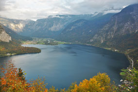
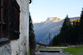
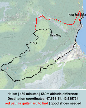
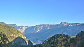
Hohe Sieg übers Echerntal
Difficulty: Advanced
11km | 180 minutes (roundtrip)
580m altitude diff.
Destination: 47.561154, 13.635734
- good shoes needed
- take water with you
- red path is quite hard to find (alternatively return the same way)
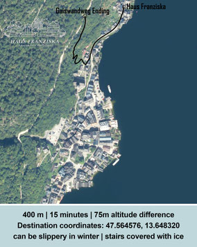
Gaiswandweg
Small hike right next to the apartment
Difficulty: Easy
400m | 15 minutes (one way)
75m altitude difference
Destination: 47.566476, 13.648320
- In Winter: quite slippery with the stairs covered in ice
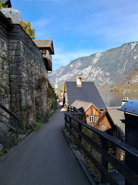
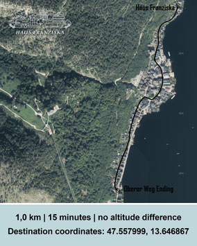
Oberer Weg
Path above the main street of Hallstatt
Difficulty: Easy
1,0km | 15min (one way)
Destination: 47.557999, 13.646867
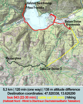
Wiesberghaus
Difficulty: Moderate
5,3km | 120min (one way)
138m altitude difference
Destination coordinates: 47.520338, 13.626200
bus 543 (22-30min)
From: Hallstatt Nord
To: Winkl b. Obertraun Dachsteinseilbahn Talstation)
cable car (Section 1+2+3 = 35min)
hiking (60min)
Simonyhütte
Difficulty: Professional
6,9km | 2std 45min (one way)
600m altitude diff.
Destination: 47.501010, 13.623213
bus 543 (22-30min)
From: Hallstatt Nord
To: Winkl b. Obertraun Dachsteinseilbahn Talstation)
cable car (Section 1+2+3 = 35min)
hiking (1std 45min)

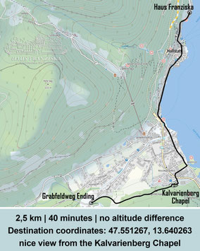
Grabfeldweg
Quit hike with a nice view from the Kalvarienberg Chapel
Difficulty: Easy
2,5km | 40 min (one way)
no altitude difference
Destination: 47.551267, 13.640263

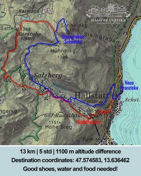
Steingraben Schneide
Difficulty: Professional
13km | 5std (round trip)
1100m altitude difference
Destination: 47.574583, 13.636462
Professional Shoes, water and food definitely needed!
Hallberg
Difficulty: Easy
2,0km | 35min (roundtrip)
50m altitude difference
Destination: 47.559705, 13.646907
Return path over Müllerstiege

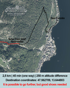
Kaiser Franz-Josef Forderstollen
Difficulty: Moderate
2,5km | 45min (one way)
250m altitude difference
Destination coordinates: 47.562709, 13.644803
It is possible to go further, but the path gets muddy - good shoes needed.
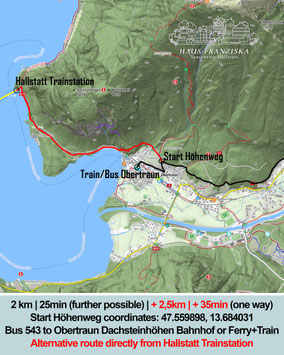
Höhenweg | Obertraun
Difficulty: Easy
2km | 25min (one way - further possible)
additional 2,5km | 35min to trainstation
Start Höhenweg: 47.559898, 13.684031
Arrival Options:
- Bus 543 to Obertraun Dachsteinhöhlen Bahnhof
- Ferry to Hallstatt Trainstation, + walk
OR train to Obertraun
Ewige Wand | Bad Goisern
Difficulty: Moderate
Destination: 47.659222, 13.619282
3 km | 60min (one way - bus)
Quite alot of altimeters/height from the bus station.
Arrival with the bus:
- Bus 544 to Hallstatt Gosaumühle
- Bus 542 to Bad Goisern Kurhotel
3km | 45min (one way - car)
Car Parking: 47.654146, 13.639426

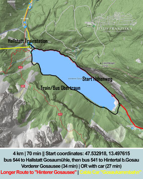
Gosausee | Gosau
Difficulty: Easy
4km | 70min | no altitude difference
Start coordinates: 47.532918, 13.497615
Arrival with bus (34min):
- Bus 544 to Hallstatt Gosaumühle
- Bus 541 to Hintertal b.Gosau Vorderer Gosausee
Longer Route to "Hinterer Gosausee"
Cable Car "Gosaukammbahn"
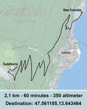
Rudolfsturm & Skywalk
CURRENTLY CLOSED
Difficulty: Moderate
2,1km | 60 min (one way)
350m altitude difference
Destination: 47.561185, 13.643464
The Salzwelten Hallstatt (salt mine, funicular, skywalk & high valley) will remain closed until summer 2026.